

When looking at the overall geography of Cameroon, it is about the size of Spain or California and is shaped somewhat like a boot. It borders Nigeria to the north, Chad to the northeast, the Central African Republic to the east, and Gabon and Equatorial Guinea to the south.
Geologically, Cameroon features diverse terrains, primarily categorized into three major zones: savannah in the north, tropical rainforests in the east, and mountainous regions in the northwest. Thanks to the fertile volcanic soils near Bafoussam and Bamenda in the west, these areas have a higher agricultural population density compared to other regions. In the western areas, coffee and cocoa are cultivated, while the hot and dry savannah climate dominates the north, where Lake Chad, wildlife reserves, and rocky cliffs can be found.
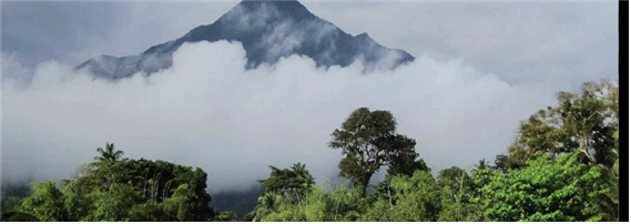
Among Cameroon's unique geographical features, Mount Cameroon stands out.
In the local language, it is called "Mongo ma Ndemi," meaning "Mountain of Greatness." Mount Cameroon is a stratovolcano located in western Cameroon, formed by accumulated volcanic deposits, and is currently an active volcano.
It is the highest mountain in sub-Saharan Africa, with an elevation of 4,040 meters. Its last eruption occurred in 2000, and there are more than 100 parasitic cones scattered across the region.
While investigating this feature, I became curious about how Mount Cameroon could still be an active volcano despite not being located on the Pacific "Ring of Fire" or the East African Rift. The reason is that Mount Cameroon lies along the Cameroon Volcanic Line. The Cameroon Volcanic Line is a chain of volcanoes stretching about 1,000 miles from the islands of the Gulf of Guinea to near Lake Chad, encompassing various mountain ranges across Africa. It is geologically unique because it cuts across both oceanic and continental crust. This phenomenon can be explained by the mantle plume hypothesis. According to this theory, relatively hot mantle material rises from the lower mantle in a narrow, powerful column. When the plume reaches the crust, it causes localized volcanic activity independent of plate boundaries, known as hotspot volcanism. Famous examples include the Hawaiian Islands, Yellowstone, and the Galápagos Islands. Similarly, the Cameroon Volcanic Line stretches from Bioko Island, across mainland Cameroon, toward the Adamawa Plateau. Thus, the Cameroon Volcanic Line is not formed by plate boundaries or rift zones but is a volcanic region caused by hotspot volcanism through a weakened lithosphere.
Moreover, it was also fascinating to realize that this geological feature is connected to the Lake Nyos disaster I had previously studied.
Questions (Q&A Section):
Q. What types of rocks are found in the Cameroon Volcanic Line, and why do these specific rock types appear?
Q. Are there geographical or chemical differences between volcanoes formed at plate boundaries and those formed by hotspot volcanism?
Q. Is the cause of the linear arrangement of the Cameroon Volcanic Line clearly understood?
I would love to see some photos showing the diverse landscapes of Cameroon!
If possible, I would also like to see some pictures of volcanoes.
Additionally, I heard there is a Reunification Monument in Yaoundé — if anyone has been there, I would love to see a photo of it as well!

These days, Korea is truly beginning to feel the arrival of spring among the four seasons. The weather is mostly clear across the country, with daytime highs expected to reach around 25°C and lows dropping to about 4°C. This is due to a high-pressure system moving from southern China toward the waters south of Jeju Island.
Fine dust levels are generally moderate in most areas, although the air quality is slightly worse in the Seoul metropolitan area and the Chungcheong region.
Additionally, a low-pressure trough moving from the West Sea to the East Sea is expected to bring rain to most parts of the country between the 12th and 13th. This is the current weather outlook for Korea.
Along with the arrival of spring in South Korea, large-scale wildfires have become increasingly common. Based on data from the past decade, 55.5% of all wildfires in the country occur between March and May, making spring the peak season for wildfire outbreaks. However, due to climate change, unpredictable high temperatures, dry conditions, and strong winds have made even the smallest sparks potential causes of devastating fires.
Forests, which once served as carbon sinks, are now burning and releasing greenhouse gases, accelerating global warming and, in turn, increasing the risk of further wildfires. As extreme weather patterns become more irregular, predicting and controlling wildfires has become more difficult, and the duration of such events is often prolonged.
In addition, South Korea, traditionally known for its temperate climate and distinct four seasons, is now experiencing frequent abnormal weather conditions such as heatwaves, sudden heavy rainfall, and high levels of fine dust. Previously, each season was mainly influenced by major air masses—such as the Siberian, Okhotsk Sea, North Pacific, and Yangtze River air masses—which maintained seasonal balance. However, rising global temperatures have altered the strength and movement of these air masses.
For example, the North Pacific air mass, which is hot and humid, is strengthening earlier than usual, causing summer to start sooner and last longer. Meanwhile, a strengthened Siberian air mass can lead to more intense cold spells in winter. These shifts have resulted in shorter spring and autumn seasons.
Furthermore, southern regions like Jeju Island are visibly shifting toward a subtropical climate. This change is disrupting local ecosystems and altering the distribution of plant and animal species.
Many countries across the African continent have been strengthening laws and regulations for years to eliminate single-use plastics. Out of Africa’s 54 nations, 34 have already introduced regulations or passed legislation to restrict the use of single-use plastics. Among them, 16 countries have either fully or partially banned plastic bags.
Cameroon, in particular, implemented a law in 2014 prohibiting non-biodegradable plastics. This legislation bans the import, production, and sale of single-use plastic products.
According to a column published by Greenpeace, the city of Douala in Cameroon has experienced frequent flooding and a decline in food quality. One of the main causes is the massive accumulation of plastic waste in drainage systems and stagnant water areas, which blocks proper water flow and circulation.
This made me curious about the geographical and environmental reasons why many African countries have commonly introduced plastic regulations. I also wonder whether introducing sustainable alternatives to plastic is truly feasible given Cameroon’s climate and geographical conditions.


This is beautiful 😍. Big ups to you Gahyeon. 👏 Your interest speaks life into this post. Thanks for sharing
ReplyDeleteExceptional and detailed write-up Gahyeon Lee. It's very immersive. Well done 👏 ✔️ 💯
ReplyDelete